 

  
3 ancient portulans
in a box - available also in wood handmade furniture (€ 2400)
ISBN 88-86251-55-6
Price: € 1750,00
|
|
PORTULANS
ancient nautical maps from the Estense library
‘Portulans’ are medieval nautical maps, provided with a wealth of geographical coastal names, conceived for being used by seafarers. Due to the fact that they used to be frequently rolled up and constantly consulted aboard, the surviving ‘carte da navigar’ are extremely rare and not always in good condition.
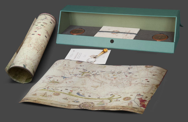
This collection of three ancient portulans, belonging to the Biblioteca Estense, is presented in a canvas showcase, together with the commentary volume, the certificate of authenticity, two wooden-bronze paperweights and a magnifier.
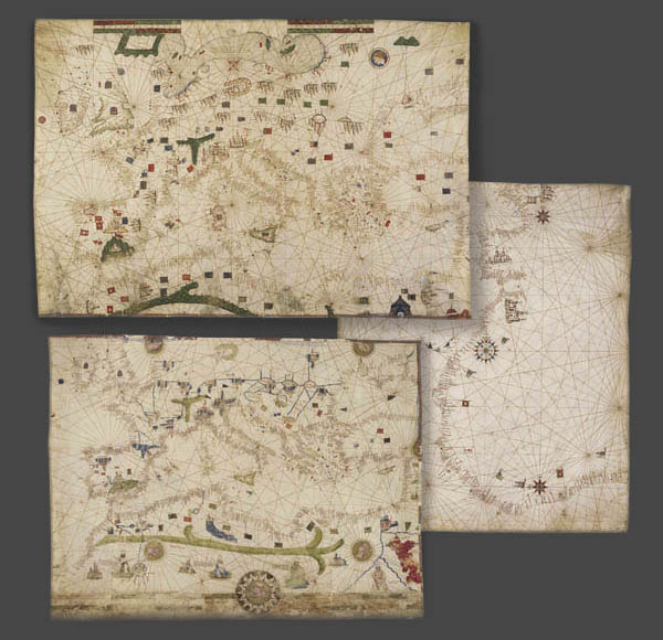
Portulan C.G.A.5.d (Majorca, 1450 ca.) 59 × 76 cm, shows the whole basin of the Mediterranean, the coasts of the Atlantic – from the British isles to Cape Bojador in Africa –, a part of Central Europe and the territories of North Africa. European places reproduced on this map are the Alps, with their T-shape, the Pyrenees, the cities of Venice, Genua, Prague, Granada and Santiago de Compostela, the Balearic Islands. In Africa the mountains of the Atlas stand out, whereas the caption near the Red Sea recalls Hebrews’ crossing during the flight from Egypt.
Portulan C.G.A.5.b (Majorca, 1450-1460 ca.), 61 × 90 cm, shows the Mediterranean basin and the Atlantic from Norway to Morocco. Less decorated than the previous one, it was likely a real ‘carta da navigar’ to be used on board by seamen. The cities of Barcelona, Valencia, Santiago de Compostela, Granada, Venice and Genua are singled out. Just few natural elements are used, whereas symbols of the human presence – such as flags, shields and towns – are used.
Portulan C.G.A.5.c is the most ancient document of Portuguese nautical cartography. Anonymous and trimmed to 60 × 73 cm, it shows the Portuguese discoveries of African coasts after the explorations of Fernando Gomes in 1471-72. The emphasis on Lisbon and Ceuta and all the flags pointing out landing-places on African coasts allowed scholars to date the map between 1472 and 1482.
|
|